Showing posts with label camping. Show all posts

Tuesday, October 2, 2018

Cedar Breaks single track.

With a long over due desire and a recent change in weekend plans, we finally made it to the Brianhead/ Cedar Breaks area to ride the pedal bikes. We chose to camp up by Navajo Lake to stay close to trails and as a great in between spot nestled in the peaking aspens. Here's what we found.
 One of the uncrowded overlooks at Cedar Breaks and a glimpse to the distant Blowhard trail by the small dot atop the distant peak (Blowhard mountain).
 Yes, it is still Milkyway season and the wind finally let up enough to shoot a few exposures looking straight south towards Navajo Lake.
 The landscape around the lake was reminiscent of Bend Oregon and the Mckenzie River sections with lava.
Lichen covered lava was only on the east end of the lake and made for a cool start to our loop up to the Virgin Rim trail.
 Insert postcard title here "               ". wish you were here! Looking south towards Zion National park.
Hard to tell just how windy it was, but that was as close to the edge as I felt confident with.
Although we did not ride the Blowhard trail together, I chose to hike up from the parking to get one shot of Amy descending the last fun narrow canyon section before the drive back.
Since we only rode the Blowhard trail on our last day, we thought a hot lap in Cedar City on the Boulder dash and Lava flow trails would be appropriate. Look at my wife slaying this section of Boulder Dash.
Both the drive there and back provided amazing displays of Gods craftsmanship in the sky.

Monday, June 1, 2015

Another 2 wheeled addition to the family, say hello to "Cavita".

We recently discovered a unique old vintage (43 years old) style of two wheeled pull behind camper, aptly named the "Campster". After some research and a few classified ads we pulled the trigger on this little gem "Cavita". My wife coined this name after its cave like feel and rounded shape. It is a blend of mostly fiberglass on a steel frame with a center pop-up roof for the stand up cooking area which adds to the venting process. The weather was perfect for her maiden voyage to Mt. Timpanogos park.
Not even 10 feet long on the inside but compared to the back of my 98 Taco very comfortable and easy towing.
Not a bad view for her first trip under new management, and she can hold 2 bikes inside. Battery operated Christmas lights..........not included.
Room to stand, cook, eat, sleep and enjoy coffee out your back door.
The 2 bikes weren't just for looks we actually heard that Sundance Mountain has some really fun singletrack so after breakfast we drove down the road to the base of Sundance ski area.

Turns out they also have lift-served biking with a Swiss Apls feel to it!
Like most ski areas in Utah and surrounding mountain states, it is as lush as can be.
Wouldn't be complete without a little pedaling, just don't forget to look at the scenery.
Archies basin is a fun little loop around the southern boundary of Sundance Mountain Resort complete with the Timpanogos range in your rear view mirror.
Let's  see, lush singletrack, big mountain snow capped views and street tacos with your favorite honey. Yum!

Tuesday, May 26, 2015

Moab, cause everybodies doin it Memorial day weekend!

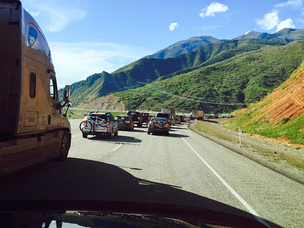
Never traveled to the bustling area of Moab over Memorial day weekend and I probably won't do it again either. The friends were great (they saved us a spot) the weather was awesome (sun, clouds, a little rain) and the trails (Gemini Bridges, Gold Bar Rim, Poison Spider) were grippy and uncrowded, but the crowds..............................WOW......................and traffic........................ (I'll show you later).
It wouldn't be Moab without a shelf road to somewhere beautiful. This was our morning commute to the Gemini Bridges, Gold Bar Rim loop and it never disappoints. We are headed up to the cliff line, upper right hand corner just below the clouds.
 If you look just above my wifes head you can see the ridgeline where we started in the previous photo.
Yes, that's a pretty big drop over the edge and you can see all the way to Green River 30 miles north.
It is hard to get the feeling with just one view so here is a look back from a pretty safe spot.
 This is looking towards the Colorado river, the La Sal mountains (fresh snow) and the edge of Moab.
That is a fracture in the rock and the yellow paint spots mark the Gold Bar rim to Portal trail mountain bike segment.

This new play area was off the Poison Spider named "where eagles dare", all slick rock.
Another one I would not want to pedal.
My wife working on her 1/4 pipe skills.
Found this ole-brown swimmin hole at the end of Poison Spider.
Same hole-different angle: It wouldn't be complete if I was'nt in one photo.
Thanks to our new dirtbike friend Lou for getting the camp spot mid-week so we could all spread our dirt bikes over the desert floor. Yes, I see at least 13 tents here.
That's my wife wrenching on her rear tire (foam insert) only to end up stuffing an old t-shirt in the space to fill the void. It's a tech-thing.
Monday was our easier ride/travel day so we opted for the Sovereign trails and once again.......uncrowded.
The traffic from the pass at Soldier summit really hit us 8 miles from the mouth of Spanish fork where this photo was taken at an average speed of 3 MPH. 
We couldn't bear the violation of our carbon footprint so we made a rest area on a side road.
Then suddenly we decided to explore the rest of the road to Diamond campground, up and over Hobble creek into Springville.
This is the Red Ledges day use area, a highly recommended stop and how about the Snoopy cloud! We also found a new way back to Salt Lake, should we ever need to avoid another Holiday weekend traffic jam.


Monday, September 22, 2014

Moab's "The Whole Enchilada" and a "Pipedream" weekend.

Camp Kopischke under a milky way sky in Moab Utah relaxing before the mexican fiesta of mountain bike rides, also known as "The Whole Enchilada".
After a shuttle ride from the awesome folks of moabcyclery.com to the trail head near Burro pass we were greeted within the first mile of our ride with this aspen grove. This was definitely the peak weekend in the La Sal mountains.

While there were just the two of us (wife and I) in our group we ended up meeting some new friends from Salt Lake that were doing the same ride, at the same time, camping in our same spot!
This patch of Aspens just past Warner Lake had to be some of the tallest I had ever enjoyed while riding my mountain bike.
Yes we have life insurance, and YES she volunteered. And yes she made it to the next great overlook.
There are numerous overlooks like this along the upper portion of the Porcupine rim trail all with perfect breezes rolling over from Castle Valley. Just to get a perspective, our 28 mile ride started up in those mountains (above shadowy ridgeline) right at the saddle below the clouds in front of my wife's nose. : )
This is one of the first views you get of the Colorado river upon your exciting descent to highway 128 just past the entry to Negro Bill Canyon.
The next day we took it easy and explored the Pipeline/Pipedream trail and were finally greeted with some nice cool clouds.
The clouds were really starting to roll in now and the breeze was cooling us off as well. Now I was hoping for some real dramatic lighting with the interesting landscape we had before us.
Amazingly enough Moab has seen a lot of rain in the last month which brought back lots of flower blooms and greenery much resembling Spring in late September.
We made it down to town in time for a great lunch at peacetreecafe.com and then watched the deluge rush over the sidewalks all throughout downtown Moab. But, like all good rain storms this one stopped long enough to make a quick dash to the natural swimming area just 5 minutes from town.
Great weekend getaway!